
Maps of the National Rail Network
View and download the official railway maps of the National Rail network in Great Britain
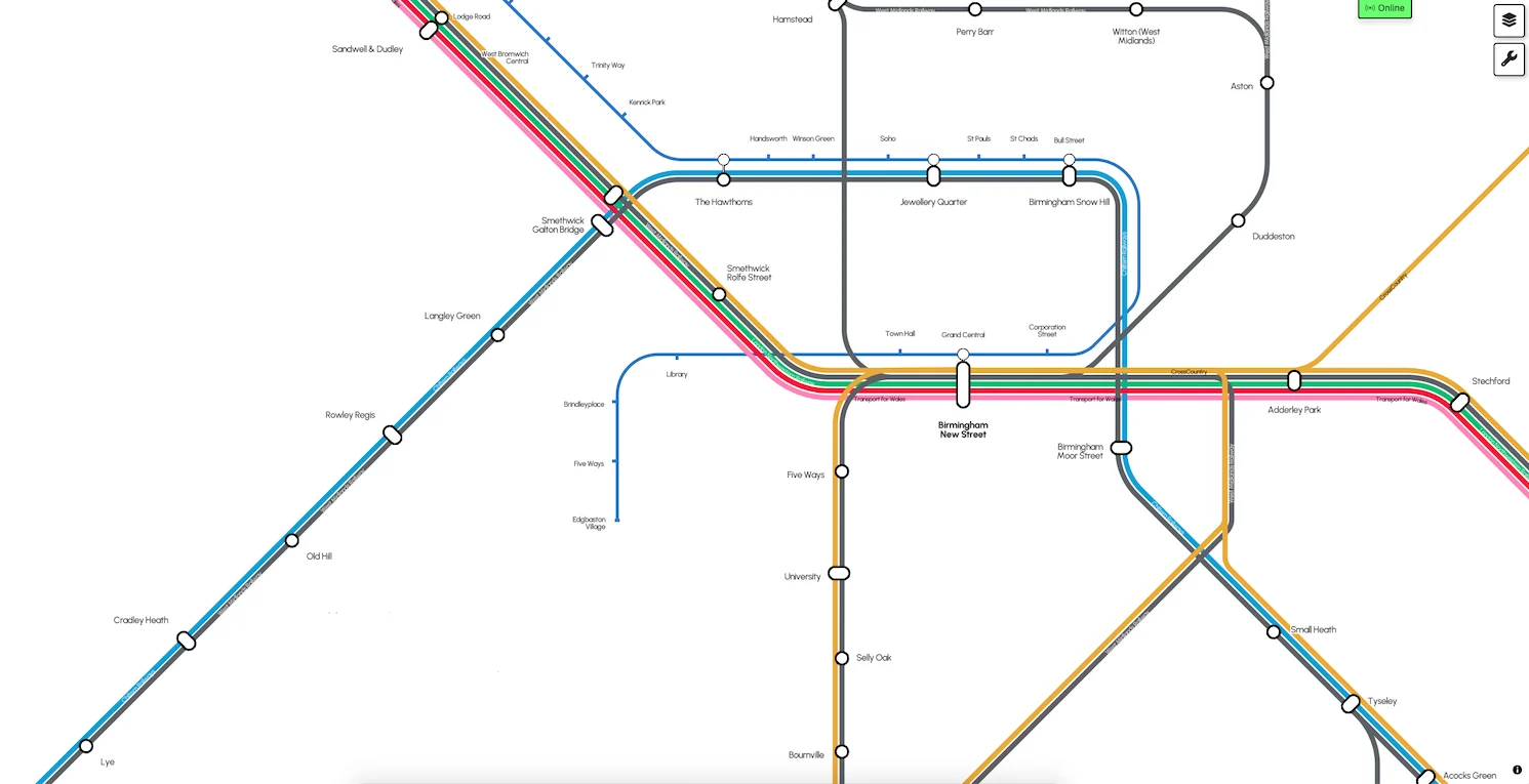
Official National Rail Interactive Route Map
This is our new official National Rail Interactive Route Map, which shows every station, every line and every train company that serves the routes in Great Britain. It also shows all non-National Rail tram and urban metro rail networks. The map is interactive and fully zoomable and will resize as you scroll, on any device.
New for April 2026, we have added station facility and accessibility information for every National Rail station. You can either use the station search function in the top left, or open the 'Station info' tab on the left menu then click any National Rail station on the map. You can also switch on the 'show step-free access' information layer, using the layer menu in the top-right corner to see at a glance the step-free status of all National Rail stations across Britain.
Throughout the rest of the year, we will be introducing many new selectable options to overlay various types of other information across the map.

Official National Rail network maps (static versions)
These are our official National Rail Route Maps as static, downloadable versions.
We have a Principal Route Map that shows a high-level overview of the main routes in Britain and an All Stations Route Map that shows every station, every line and every train company that serves the routes - and also shows all non-National Rail tram and metro networks and ferry routes that connect with or near stations. Both maps can be downloaded as a PDF document.
National Rail Principal Route Map
This map is a simplified overview of the principal lines and stations in Great Britain. Not all lines and stations are shown. For a map showing all lines, all stations, use the National Rail All Stations Route Map. (26 March 2026 - PDF, 2.1Mb)
National Rail All Stations Route Map
This map shows the entire National Rail network in Great Britain. It shows all lines, all stations and all Train Company routes that serve them. (26 March 2026 - PDF, 2Mb)


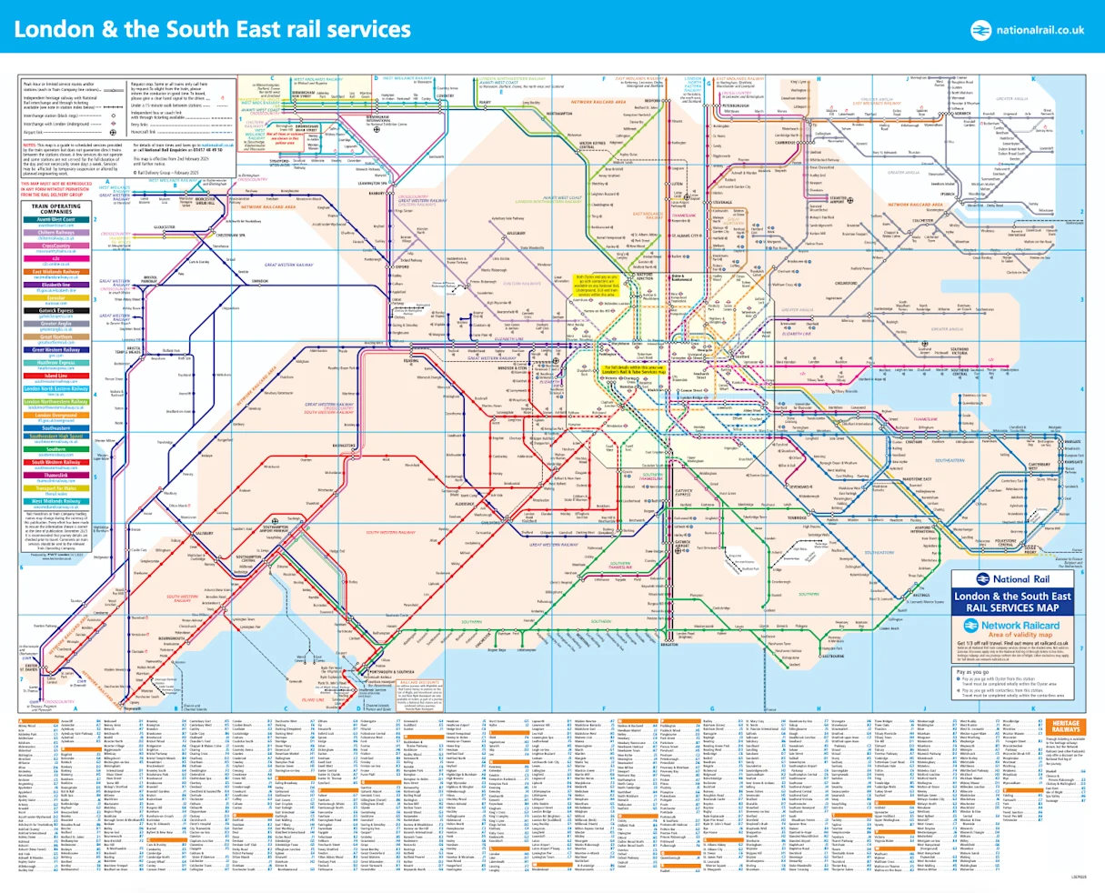
London and South East area route maps
London & South East Rail Map
Map of all National Rail routes and stations in the South East, also showing the Network Railcard area. (March 2026 edition. PDF, 1.6 MB)
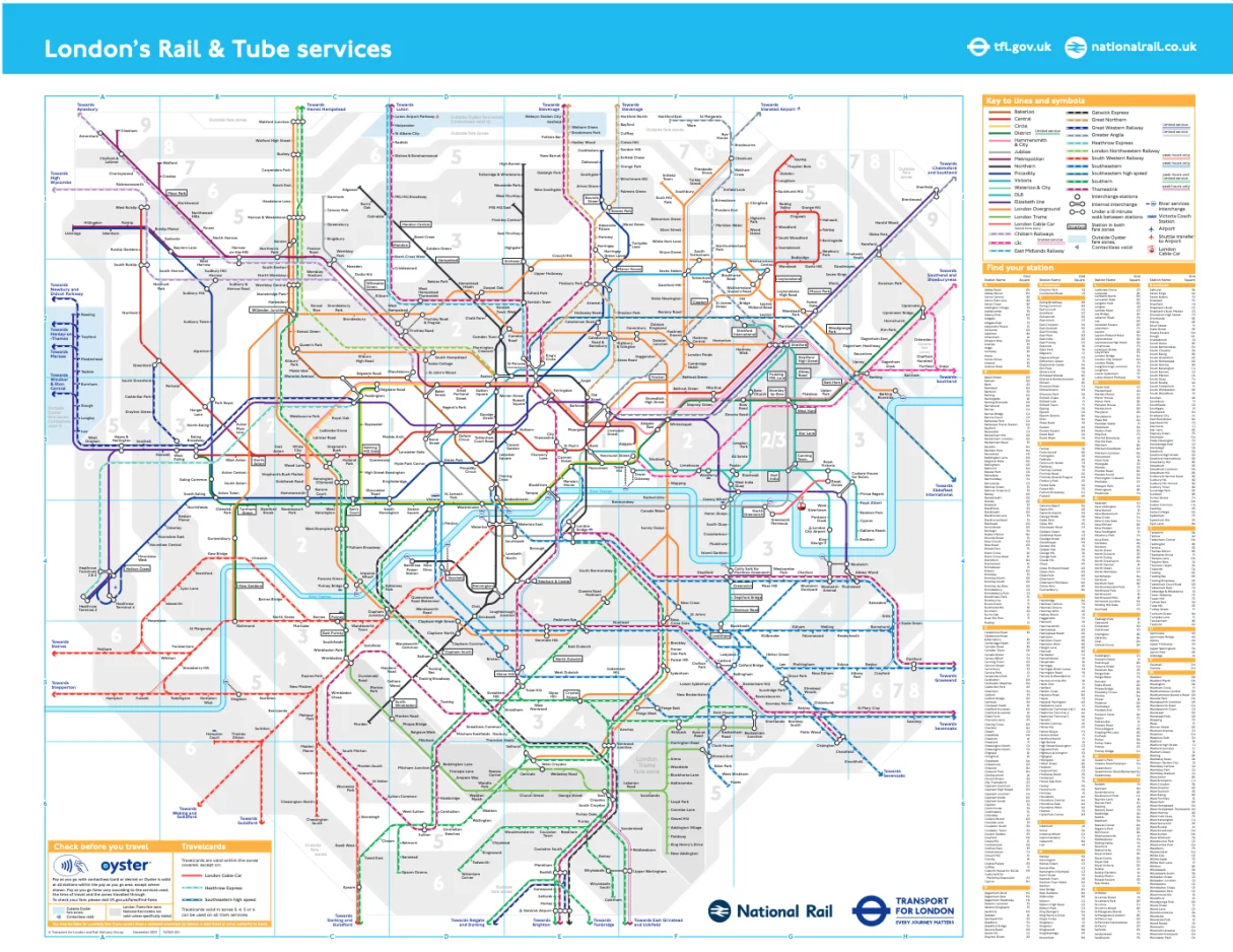
London's Rail & Tube Map
Map of all National Rail, London Underground, DLR and London Tram routes and stations within the Greater London area and beyond. (July 2025 edition. PDF, 2.9MB)
National Rail station accessibility map
Station accessibility information is available on the National Rail Interactive Route Map, where you can switch on the 'show step-free access' information layer, using the layer menu in the top-right corner to see at a glance the step-free status of all National Rail stations across Britain. The key to the step-free access symbols is on the left hand side.
You can use the station search function in the top left - or open the 'Station info' tab on the left menu then click any National Rail station on the map. This allows you to tab between general station facilities and accessibility specific information for each station. This information is only available to us for National Rail served stations. Use the layer menu to uncheck the box marked 'show tube/tram routes' to show only National Rail-served stations.
Click the left thumbnail picture below to load the National Rail Interactive Route Map with the station accessibility layer already switched on. A text-only version of this station accessibility information without the map, suitable for those using screenreaders to hear the accessibility status and features, is available by clicking the right-hand thumbnail below.
National Rail station and accessibility information
The National Rail Interactive Route Map with the station accessibility information layer already switched on for all National Rail served stations. Use the 'find station' feature or open 'Station info' tab and click on any National Rail station.
National Rail station accessibility information (screenreader text-only version)
A text-only version of the station accessibility information from the National Rail Interactive Route Map, suitable for those using screenreaders to hear the accessibility status and features for all National Rail served stations.


Onward travel from station and local area maps
We also have maps that show the local area around National Rail stations, plus they include onward travel information such as bus routes, taxi ranks and cycle hire. They are not available for all stations.
To find local area maps, visit our Find a Station page and enter the name of the station you require. If there is a link called Onward Travel Information Map then this local travel information is available.
© Copyright Conditions.
The copyright for all the maps on this page belong solely to Rail Delivery Group, working on behalf of National Rail and its members. The London's Rail & Tube Map is joint copyright between Rail Delivery Group and Transport for London.
All rights reserved. Except solely for your own personal and non-commercial use, no part of any map may be copied or used without the prior written permission of the copyright holder. By following a link to the map it is understood that you have read this notice and accept the conditions.