
From Rails to Trails
Get off the beaten track with 11 of the best scenic walking and cycling paths that run along old railway lines
The rail network today spans around 10,000 miles, but there are many stretches that were closed down decades ago. Some of these disused lines have been given new life as trails for walking, cycling and horse-riding. Located all around Great Britain, lots of the trails are within reach of stations, and offer a chance to get out into nature. But you can still spot the old trackbeds, stations, tunnels, bridges and viaducts that reveal their railway past.
We’ve rounded up 11 of the trails below, as well as the nearest current stations to get there by train.
While we have tried to provide broad accessibility details for the trails themselves, we recommend you check the distance from the station to the trail, and that the route is suitable, before you travel.
1. The Cuckoo Trail, East Sussex

This 11-mile path follows the route of the old Cuckoo Line railway track from Heathfield to Polegate. The railway opened in 1880 and closed in 1968, and got its name from the tradition of releasing a cuckoo at Heathfield Fair every spring. The trail goes through woodland and open pasture, with plenty of opportunities to enjoy nature, but you can also spot the old bridges and tunnels from its previous incarnation.
The track is paved, suitable for walking and cycling, and is accessible to all.
Nearest stations to the Cuckoo Trail: Polegate, Hampden Park
2. The Crab and Winkle Way, Kent
The trail runs for 7.5 miles between Canterbury and Whitstable on the line of the old railway, which was called the Crab and Winkle line due to the seafood caught in Whitstable. It was one of the first passenger train lines, opening in 1830, but closed permanently in 1952. The path links the city of Canterbury, with its ancient cathedral, with the trendy seaside destination of Whitstable, via ancient woodland and small villages.
The path is mostly traffic-free, and suitable for walking and cycling, but there are some steep hills so it may not be accessible for all.
Nearest stations to the Crab and Winkle Way: Canterbury West, Whitstable
3. The Monsal Trail, Peak District

Set in the Peak District National Park, the Monsal Trail is 8.5 miles long and runs along the former Manchester to London Midland Railway line, which closed in the late 1960s. There are a number of nature reserves along the route, as well as 6 former rail tunnels and the famous Headstone Viaduct. The old Millers Dale and Hassop stations are now cafes, and there is a visitor centre in the redeveloped Goods Shed at Millers Dale.
The trail is traffic-free and suitable for all, but you may need to catch a bus from the station to the trail.
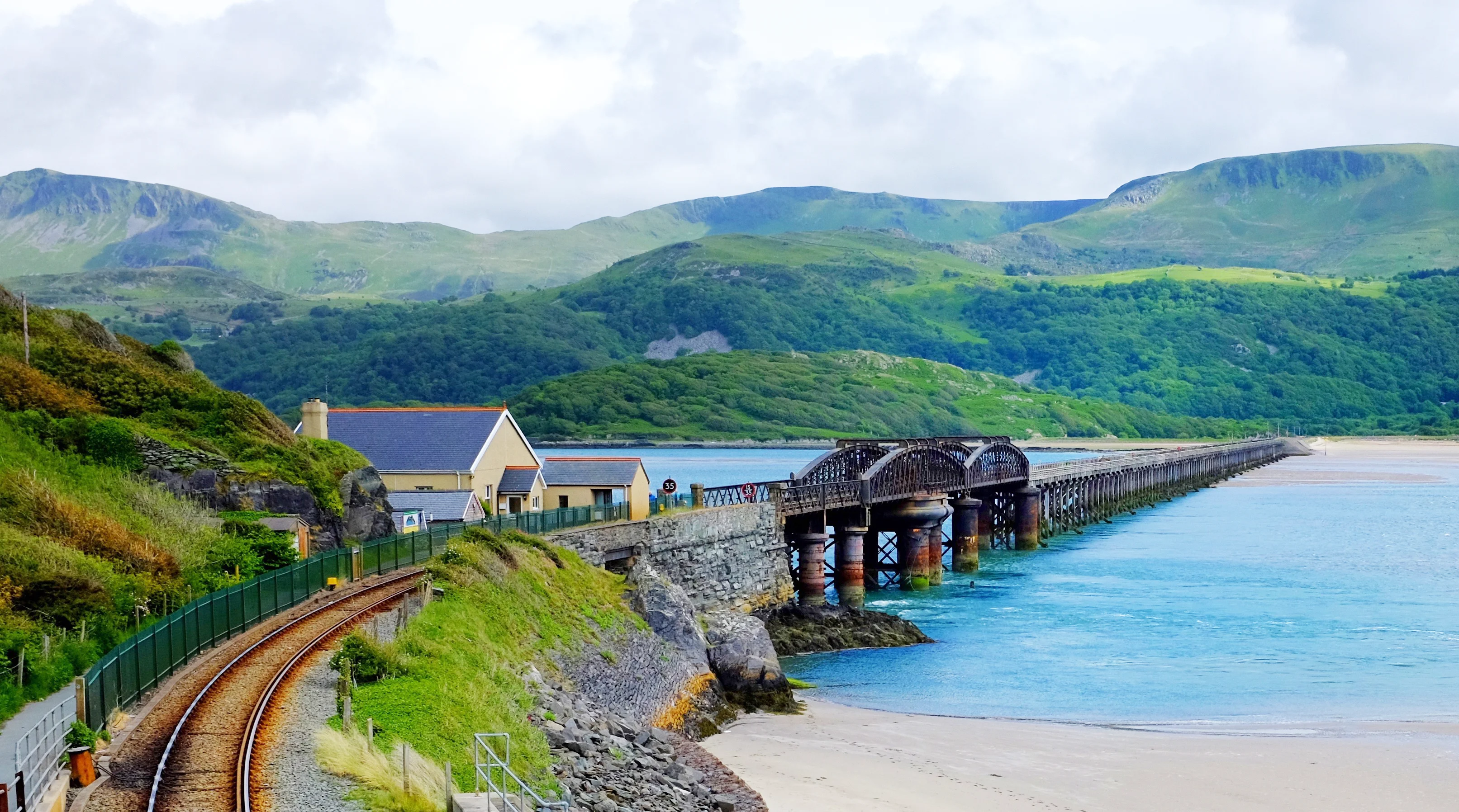
4. The Mawddach Trail, Gwynned
Following the track of the old railway line around the edge of the beautiful Maddach Estuary in Snowdonia/Eryri (a site of special scientific interest), this 9.5 mile trail goes from Dolgellau to Barmouth, where you can cross the famous Grade II* listed bridge. Along the route there are 2 RSPB reserves, as well as a former gold mine on the north side of the estuary.
The trail is largely flat, even, wide and traffic-free, making it suitable for all users.
Nearest stations to the Mawddach Trail: Morfa Mawddach, Barmouth
5. The Camel Trail, Cornwall

This 18-mile trail links Padstow, Wadebridge and Bodmin along the route of the old London to Padstow rail line. It was originally built to transport sand from the Camel estuary in the 1830s, but closed in 1983. The trail follows some of the path of the River Camel, and passes through marshes and woodlands, before reaching the sea.
The trail is flat and has a hard surface, and is suitable for all.
Nearest station to the Camel Trail: Bodmin Parkway
6. The Flitch Way, Essex

Travelling 15 miles from Braintree to Start Hill, the Flitch Way follows the old Great Eastern Railway line that opened in 1869 and closed to passenger trains in 1952 (although freight continued until 1971). The name flitch means a side of bacon, which would be given to couples in the village of Little Dunmow who had not argued for a year and day of their marriage. You can drop in and out of the path at many places, with sights along the way including Great Notley Country Park, the old Rayne station which is now a café, and Hatfield Forest.
The trail is largely flat, surfaced and traffic-free. Most of the route is suitable for all users.
Nearest stations to the Flitch Way: Braintree, Bishops Stortford
7. The Wirral Way, Merseyside/Cheshire

Set within Wirral Country Park, this trail runs 12 miles from West Kirby to Hooton. It follows the trackbed of the old railway , which is the missing section of what used to be a circuit of Wirral. You can look all the way across the Dee Estuary toward Wales, and there is a wealth of plant and animal life to discover within the park. The former Hadlow Road station in Willaston is Grade II listed and now operates as a museum, with many of the original features preserved.
Most of the path is suitable for all users.
Nearest stations to the Wirral Way: West Kirby, Hooton
8. The Cinder Track, Yorkshire
This country and coastal path connects Whitby with Scarborough, running nearly 22 miles through the North York Moors National Park, along the railway line that closed in 1965 (the original trackbed was laid with cinders, giving the route its name). Sights to look out for include the views of Robin Hood’s Bay, the old Hayburn Wyke and Ravenscar stations, and Larpool Viaduct, from where you can see Whitby Abbey.
Most of the path is suitable for all users. There are some sections that are steep, or have steps, and are therefore less accessible.
Nearest stations to the Cinder Track: Whitby, Scarborough
9. The Granite Way, Devon

This Dartmoor trail runs 11 miles, from Okehampton to Lydford, along the former Southern Region railway. As well as travelling through the beautiful moorland and seeing the granite rocks that give the path its name, you can cross the impressive Meldon Viaduct and take in the spectacular views.
The trail is traffic-free and surfaced, and suitable for all.
Nearest station to the Granite Way: Okehampton
10. The Parkland Walk, London
Running between Finsbury Park and Alexandra Palace, on the track of the former Edgware, Highgate and London Railway, this 4.5 mile nature reserve is a green oasis in North London. There is a wildlife trail, ponds and meadows, but benches made of railway sleepers and other reminders of the area’s railway past are visible in the greenery, along with the remains of the old Crouch End station’s platforms.
There are some steep stairs and not all of the trail is accessible.
Nearest stations to the Parkland Walk: Finsbury Park, Alexandra Palace
11. The Innocent Railway Path, Edinburgh

Part of the former Edinburgh and Dalkeith Railway, this 2.5 mile path connects St Leonards, Duddingston and Brunstane. One of the most impressive parts is a stone tunnel running right under Holyrood Park, which was originally used by horse-drawn trams to transport coal and was the first railway tunnel in Scotland. As well as Holyrood Park and Arthur’s Seat, the trail includes the Bawsinch and Duddingston Nature Reserve, and from Brunstane you are only a walk away from the coast.
The path is mostly flat but some entry points might not be fully accessible.
Get 1/3 off train fares with a Railcard
Save up to 1/3 off your trips when you travel by train with a Railcard
From children to seniors, over 20 million people in Great Britain can save with a Railcard. See which one is right for you
Buy yours today for just £35 and you’ll make the cost back in 1 or 2 trips!

You might also like
Nature Bathing by Train
Take the train for journeys into nature that bring the senses alive and help calm the mind and cleanse the soul
The Best Places for Dark Skies and Stargazing
Get outdoors and see nature’s light show at these official Dark Sky destinations across Great Britain
Visit Great Britain’s Great Gardens
Escape the city and relax in the great outdoors. Explore wonderful gardens, from Kew to Birmingham Botanical Gardens, for less, when you travel by train


Frenches Halt, Cuckoo Trail image credit: © by PAUL FARMER(external link, opens in a new tab) is licensed under CC BY-SA 2.0(external link, opens in a new tab).
Camel Trail image credit: © by Andy F(external link, opens in a new tab) is licensed under CC BY 3.0(external link, opens in a new tab).
Granite Way image credit: © by Rosser1954(external link, opens in a new tab) is licensed under CC BY-SA 4.0(external link, opens in a new tab).
Innocent Railway Tunnel image credit: © by @andrewghayes(external link, opens in a new tab) is licensed under CC BY-NC 2.0(external link, opens in a new tab).
Advertisement